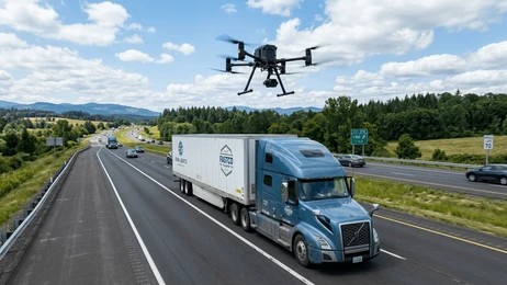
A truck leaves the depot at first light, loaded and sealed. Ahead of it lie hundreds of kilometres of road. Somewhere along that route, the corridor narrows and traffic slows. The vehicle then enters a stretch where signal fades and help is far away. For the operator watching a dot cross a screen, this is the hardest part of the job. The dot keeps moving. Yet nobody can see what is happening around it.
That blind spot is where freight is lost. Cargo security monitoring from the air is closing it. It places an intelligent, high-resolution eye above depots, delivery corridors, and the roads between them. As a result, operators gain something a tracker alone cannot give them. They gain a live view of the world their cargo is moving through.
The Blind Spots in a Modern Supply Chain
Freight operators already collect a great deal of data. Telematics report speed, location, and fuel. Seals and sensors flag a door that opens when it should not. Even so, all of this describes the vehicle. Almost none of it describes the world around the vehicle.
That distinction matters. A tracker will tell you that a truck has stopped. It will not tell you why, or who is approaching it. Similarly, a depot fence marks a boundary. Yet it cannot watch a yard at three in the morning. Meanwhile, the corridor itself changes constantly. A bridge deteriorates. Elsewhere, a road washes out. Suddenly, a diversion sends drivers onto an unfamiliar route. Consequently, decisions get made with half the picture, and risk quietly builds across the network.
Cargo Security Monitoring From Above
This is where cargo security monitoring from a capable aerial platform earns its place. The DJI Matrice 4T carries an entire monitoring toolkit on a single compact airframe, and it deploys in minutes.
Its high-magnification zoom reads fine detail from a considerable distance. An operator can therefore observe a yard, a queue, or a stopped vehicle without drawing attention. A radiometric thermal camera then works where light fails. It picks out people and warm engines in complete darkness. On top of that, onboard intelligence recognises vehicles and people automatically, and it raises an alert. Finally, a laser rangefinder fixes the precise position of whatever the aircraft finds. In practice, that turns a distant sighting into an actionable location.
Deterrence, Response, and Route Intelligence
Cargo security monitoring delivers value in three distinct ways, and each one matters to a different part of the business.
Deterrence comes first. A depot known to be watched from above becomes a far less attractive target. Much of the value here lies in the incidents that never happen at all. Response comes next. Something may still occur, whether a breach, a hijacking attempt, or an accident. In those moments, a drone puts eyes over the scene quickly. The control room then receives a live picture rather than a phone call. Route intelligence completes the set. Flown across a corridor in advance, the same aircraft assesses conditions and identifies chokepoints. Planners can then judge which route carries the least risk today.
From Corridor Data to Supply Chain Visibility
The corridor itself is an asset. Its condition shapes every delivery that travels it. Aerial inspection documents that condition precisely. Bridges, culverts, road surfaces, and access points are all surveyed from the air. Better still, they are recorded over time. With GIS mapping, those findings become more than photographs. Instead, they become located, measurable data on an accurate map of the route.
That data compounds. Captured regularly, it feeds operational analytics and supply chain visibility dashboards. Planners can then watch how a corridor changes over time. They no longer react to each surprise as it arrives. As a result, route planning shifts from instinct to evidence. Infrastructure condition reporting also becomes a scheduled output rather than an emergency. Ultimately, better visibility upstream means fewer costly disruptions downstream. That is the quiet return on cargo security monitoring.
A Partner Built on Standards
In logistics, capability alone is not enough. Cargo security monitoring only works when it is delivered consistently. Operators therefore need partners who work to a standard, and who can prove it.
ARCO Worldwide equips logistics and transport operators with aerial intelligence and real-time data solutions that strengthen route visibility, infrastructure monitoring, cargo security, and last-mile efficiency. Our operations hold NCAA authorisation for commercial aerial work in Nigeria, and our delivery is governed by ISO 9001:2015 certified operational standards. As Nigeria’s first DJI Enterprise Authorized Partner, we combine high-resolution optical and thermal payloads with corridor monitoring experience and GIS mapping capability for route planning and infrastructure documentation.
Cargo moves through the world, not through a screen. Cargo security monitoring simply gives operators the means to see that world clearly, and to act on what they find while it still matters.
Ready to bring cargo security monitoring and route intelligence to your network? Get in touch with ARCO Worldwide.-