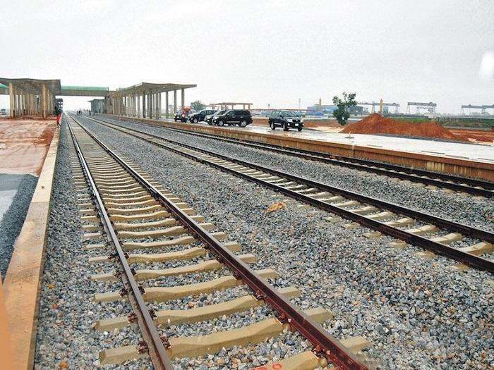
A rail line is a long, thin asset with a short list of access points. That geometry defines every maintenance problem it has.
Inspection teams reach the corridor where roads meet it, then walk. Meanwhile most of the alignment sits between those points, unobserved. Rail inspection in Nigeria works better when the corridor is viewed as a continuous strip rather than a series of visits.
What makes rail corridors hard to monitor
Three conditions recur across the network.
Length against access. Hundreds of kilometres of track, reachable from comparatively few roads. Remote sections receive the least attention, and they are often the ones carrying the most exposure.
Operational windows. Inspecting track means working around traffic. Possessions are limited, and anything that needs the line closed competes with everything else that needs the line closed.
Encroachment. Settlements, markets, farming and informal crossings appear along the right of way over time. Each creates a safety exposure, and nobody notices the early stages from a passing cab.
What aerial capture adds
A drone follows the alignment rather than the road network.
Within a single campaign, you document formation, drainage, cuttings, embankments, bridges, culverts and level crossings along the full length. Nothing depends on where a vehicle could park.
Because the flight path repeats, comparison becomes possible. Erosion at an embankment, scour at a culvert, new structures inside the boundary and vegetation growth over sightlines all become measurable between captures rather than noticed late.
Crucially, most of this happens without a possession. The aircraft works above the corridor while trains continue running.
Best-fit platforms and payloads
Payload choice follows the question.
Matrice 350 RTK with Zenmuse L2 handles LiDAR. Point clouds support clearance measurement, cutting and embankment geometry, drainage modelling and vegetation profiling. Laser returns also penetrate cover, which matters on sections where growth has closed in.
Zenmuse P1 delivers photogrammetric corridor mapping for records, planning and progress documentation.
Zenmuse H30T adds zoom and thermal for structures. Bridges, culverts, signalling cabinets and electrical equipment all benefit from detail captured at a safe standoff.
Matrice 400 extends coverage across long sections in a single flight, which reduces launch points along a dispersed alignment.
Where specific locations need persistent watching, DJI Dock 3 with the Matrice 4TD flies automated routes on a schedule. Depots, yards, known encroachment hotspots and high-value structures suit that approach, including after dark.
What rail operators receive
Under our Drone as a Service model, ARCO Worldwide delivers:
- Orthomosaic corridor mapping along the full alignment
- LiDAR point clouds for clearance, geometry and drainage
- Structural condition reports for bridges, culverts and retaining walls
- Right-of-way encroachment mapping with change detection
- Vegetation and sightline assessment at crossings
- Erosion, scour and embankment movement monitoring
- Incident and damage assessment with timestamped imagery
- GIS-ready datasets for asset registers
Your engineering and safety teams receive evidence against location. We manage the aviation.
Security along the line
Rail assets attract theft, and components disappear from remote sections precisely because they are remote.
Scheduled aerial patrols document condition and presence along the corridor. Thermal coverage extends that into the night, when most interference occurs. Change detection then flags what was not there last time.
Construction and expansion
Nigeria continues to invest in rail, and new alignments need the same data earlier.
Pre-construction corridor survey tests a proposed route against real terrain. During construction, repeat capture tracks progress and earthworks volumes. On completion, the final survey becomes the as-built baseline that every later inspection compares against.
Why the operator matters
Flying along a live railway crosses roads, settlements and sometimes controlled airspace, so authorisation and coordination come first.
ARCO Worldwide Sevices is Nigeria’s first licensed commercial drone operator, authorised by the NCAA for nationwide commercial operations and approved by the Office of the National Security Adviser. Our inspection reporting runs under ISO 9001:2015 certified processes, which supports BPP-compliant submissions for public sector work.
With bases in Lagos, Abuja and Port Harcourt, we mobilise along corridors across the country.
See the line, not the access points
A corridor inspected only where roads reach it is a corridor mostly unseen.
Aerial rail inspection in Nigeria covers the whole alignment, records it consistently, and turns each capture into a comparison with the last.
Ready to survey your network? Talk to ARCO Worldwide today.